 |
 |
|||||
Get the most out of modern electronic charts,
and be prepared for the end of paper charts as we know them.
|
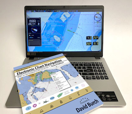
Electronic Chart Navigation Online Course
From basic echart reading to advanced route planning, to make your time on the water safer and more efficient.
This course introduces you to a new world of charting and navigation technology available in modern navigation software.
$349.00 ...item# 1926
|
 |
||||||
|
Includes printed copy of our textbook Introduction to Electronic Chart Navigation plus a custom set of training charts and extensive support materials.
NOAA's ongoing program of ending the production and distribution all paper charts and their rasterized echart counterparts (RNC) will be completed by the end of 2024, to be replaced with all ENC (electronic navigational charts) and the new NOAA Custom Charts (NCC) based on these ENC. This seems a radical step, but as we show in this course, this will all soon be recognized as a giant step forward, leading to more comprehensive, convenient, and safer navigation and the new NCC paper charts will indeed eventually be superior to what we are used to. But much of this is new to many mariners, so it takes training to fully appreciate that. No need to wait till they are the only option. All mariners have access to these ENC and NCC right now, so you can practice with them on your own local waters as we work though examples in class. These charts are updated weekly, and easy to install. ENCs include much more information than traditional paper charts or RNC. They are in effect charts, Light Lists, and some elements of Coast Pilots combined, plus interactive, annotated Tide and Current Tables—the program we use has one of the best tide and current displays available. But ENC require new methods of chart reading and how we interact with charts during navigation. This course teaches the practical use of ENC, focusing on the advantages of their unique features. Students will master the use of the powerful navigation and weather program qtVlm. There is a PC and Mac version, plus mobile app versions, but the mobile apps are not covered in the course nor included with it. If you have a favorite navigation program already, it should be easy to adapt what you learn here to it—or carry on using qtVlm, a program that you will know very well when done with the course. Even if you are a seasoned navigator in traditional methods, this course will bring you up to speed in echart operations and procedures. Indeed, if you are certified in coastal navigation, this is the logical next step in your training. We also cover how to produce and then print the new NOAA Custom Charts (NCC). These are user defined ENCs that can be printed in regular chart sizes or smaller to meet your needs. There are many convenient, inexpensive printing options. These will be the replacements available for those who will continue to want a printed chart on the chart table—it is hard to argue against the virtue of that, even though ships have not been required to carry paper charts for a long time now. The NCC program is still in development, but we can look forward to paper charts of our own design that will be superior to what we are used to. Because qtVlm is such a sophisticated marine weather resource as well, we can incorporate the awareness of the wind into all course reckonings, under power or sail. The latest wind and waves forecast over the chart in view can be added with a button click. Sailors have an optional lesson on how to use a polar diagram to compute optimum routes under sail. The lessons included are ...see Lessons link under Online Course below for details. 01.1 — INTRODUCTION TO ELECTRONIC CHART SYSTEMS (ECS) 02.1 — ENC BASICS 03.1 — TIDES, LIGHTS, and HAZARDS 04.1 — CHART READING SUMMARY and RESCHEMING 05.1 — TIDAL CURRENTS and PILOTING 06.1 — WAYPOINTS and ROUTES 07.1 — USE OF SIMULATOR AND PRACTICE WITH LIVE GPS 08.1 — ECHART NAVIGATION UNDERWAY 09.1 — AUTOMATIC IDENTIFICATION SYSTEM (AIS) 10.1 — NOAA CUSTOM CHARTS (NCC) and WEATHER OVERLAYS (GRIBS) 11.1 — INTRODUCTION TO OPTIMUM SAILBOAT ROUTING (OPTIONAL LESSON)
 This course will prepare you for certification tests offered by any maritime agency or association in any nation. We also offer our own certification tests if you care to challenge yourself this way or to prepare for other tests. All students also have full access to our complete database of USCG license exam questions, which they can filter by subject or keyword. |
|||||||
